Kim Chong-ho, Father of Korean Cartography and his "Complete Map of the Great East"
December 1, 2007-January 31, 2008
Location: Asia Collection
In 1861 the enigmatic Korean cartographer Kim Chong-ho produced a map of his country that until his day and for many years afterward was the most accurate, detailed, and shall we say "user friendly" map of Korea ever produced. Both Kim and his map remain today the foci of scholarly attention and Korean national pride.
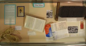
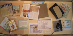
This display sought to introduce both Kim Chong-ho the figure and the great map he produced: Taedong yojido, or "Complete Map of the Great East". In a series of three display cases were presented Kim Chong-ho the man, his unique and groundbreaking map, and finally the legacy that Kim left behind. Included in the final case are Hamilton library resources, including maps, books, and even electronic resources, concerning Kim and his map.
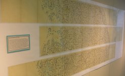
This exhibit was the first collaboration between the Hamilton Library's Asia Collection and the Map Collection. One of the exhibit's highlights is 1:5 scale reproduction of the map which was accomplished by scanning each of the map's 22 individual elongated sheets, stitching them together digitally, and printing the resulting image out using the library's newly acquired map scanner and printer. The exhibit runs from December 1, 2007 to January 31, 2008.
 |
|