
Fig. 2.20. Some of the seas around Europe and Africa. The narrow Strait of Gibraltar connects the Mediterranean to the Atlantic ocean basin.
Image adapted from Wikipedia, modified by Brittany Supnet
Fig. 2.20. Some of the seas around Europe and Africa. The narrow Strait of Gibraltar connects the Mediterranean to the Atlantic ocean basin.
Image adapted from Wikipedia, modified by Brittany Supnet
Marginal seas are large, shallow bodies of water along continental edges or margins. Marginal seas include the Arabian Sea, the Baltic Sea, the Bering Sea, the Beaufort Sea, the Black Sea, the Gulf of California, the Gulf of Mexico, the Red Sea, and the Mediterranean Sea (Fig. 2.20).
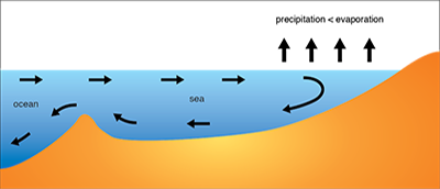
The Mediterranean Sea is an example of a marginal sea where thermohaline circulation drives water flow. Seasonal winds blow over the Mediterranean Sea causing intense evaporation of surface water. This evaporation can exceed freshwater inputs from rainwater and river runoff, increasing the salinity of the surface water. The dense surface water sinks, forming bottom water (Fig 2.21). Dense bottom water then flows out into the Atlantic ocean basin through the Strait of Gibraltar, which is a narrow opening that separates the Mediterranean Sea from the Atlantic ocean basin. Water from the Atlantic ocean basin flows into the Mediterranean Sea to replace the water that has evaporated. The water from the Atlantic ocean basin is less salty and less dense and thus remains on the surface of the Mediterranean Sea. There is a net movement of water into the Mediterranean Sea due to the water lost by evaporation. A similar thermohaline circulation pattern occurs in areas like the Red Sea and the Persian Gulf.

Fig 2.21. (A) Thermohaline circulation in the Mediterranean Sea is driven by high rates of evaporation. Salty dense water sinks and less dense water from the Atlantic ocean basin flows into the sea.
Image by Byron Inouye

Fig 2.21. (B) Thermohaline circulation in the Baltic Sea is driven by high rates of precipitation and runoff. Less dense water flows out of the sea on the surface and denser water flows in along the ocean floor.
Image by Byron Inouye

Fig. 2.22. Geirangerfjord, a fjord in Norway
Image courtesy of Bernard bill5 and Kameraad Pjotr from Wikipedia
The opposite circulation pattern occurs in marginal seas where fresh water input in the form of precipitation or runoff exceeds water lost due to evaporation. For example, in the Baltic Sea fresher, less dense water (brackish water) remains at the surface of the sea. There is a large amount of brackish water due to the amount of fresh water that empties into the Baltic Sea from rivers. This less salty water flows out of the sea while saltier, denser water flows in from the Atlantic ocean basin along the bottom (Fig. 2.21). There is a net movement of water out of the Baltic Sea due to the abundant freshwater runoff. This circulation pattern is also found on a smaller scale in fjords, deep, narrow inlets cut between steep cliffs by glaciers. Fjords are common in Norway, Greenland, and on the high-latitude coasts of North America (Fig. 2.22).
</p>")
Fig. 2.23. The Elwha River estuary in the US state of Washington
Image courtesy of United States Geological Service (USGS)
Estuaries are relatively shallow, partially enclosed bodies of water that connect to the ocean and have one or more rivers or streams flowing into them (Fig. 2.23). The freshwater outflow of the river mixes with the tidal inflow of seawater from the ocean (Fig. 2.24). Salinity is highest at the mouth of the estuary, which opens to the sea. Freshwater from rivers and streams flows into the head of the estuary, where salinity is lowest. Estuaries can be described and classified based on how they were formed or by their water circulation and mixing patterns. In the waters between the mouth and the head of the estuary, circulation patterns vary based on the size, shape, and depth of the estuary as well as wave action, winds, tides, temperature, and season. The main classes of estuaries based on circulation patterns are salt wedge, slightly stratified, and vertically mixed. Although these categories simplify the complex interaction of variables involved in estuarine water circulation, they are useful when describing how the different classes of estuaries are similar and different.

Fig. 2.24. In this diagram of an estuary, the mouth of the estuary is where ocean water flows in (dark blue) and the head of the estuary is where freshwater flows in (light blue). Mixing of these waters can lead to patterns of stratification.
Image by Byron Inouye
When a rapidly flowing river discharges into the ocean where tidal currents are weak, a salt-wedge stratification pattern develops. This means that the force of the fresh water flowing into the ocean is greater than the force of tidal currents pushing salt water up the river. The less dense fresh river water floats above the seawater, creating a boundary between the two water masses (Fig. 2.25 A). A side-view of this type of estuary shows the seawater forming a distinct “wedge” shape. Salt-wedge estuaries are the most stratified, or least mixed, type of estuary. Examples of salt-wedge estuaries in the United States include the Columbia River in Washington, the Hudson River in New York, and the Mississippi River in Louisiana.

Fig. 2.25. Vertical salinity profiles for three types of estuaries (A) salt-wedge, (B) slightly stratified, and (C) vertically mixed.
Images by Byorn Inouye
If the flow of a river into an estuary is less forceful, a less stratified pattern results in the estuary. In a slightly stratified estuary, the lower layers of water are still saltier than the upper layers, but there is not a distinct wedge. Slightly stratified estuaries are similar to salt-wedge estuaries in that estuary water is saltier near the mouth of the estuary and fresher near the head (Fig. 2.25 B). However, unlike salt-wedge estuaries, there is some vertical mixing that occurs. Deep estuaries like the San Francisco Bay in California and the Chesapeake Bay on the Atlantic coast of the United States are examples of slightly stratified estuaries.
Complete mixing in estuaries is rare, but does occur under certain conditions. In vertically mixed estuaries, intense mixing can occur during periods of low freshwater input and very high tidal range. In these cases the amount of freshwater input is insignificant compared with mixing caused by the volume of water moving in and out with the tides (Fig. 2.25 C). Large, shallow estuaries can have vertically mixed stratification patterns. The Delaware Bay on the Atlantic coast of the United States is one example of this type of estuary.
Estuaries can also occur in areas where rivers meet large freshwater lakes such as the Great Lakes. While there is no seawater in freshwater estuaries, river water still meets chemically distinct lake water and stratification can occur. Mixing in freshwater estuaries is not driven by tides, as tides in lakes are small, but rather by density effects and surges due to storms and seiches. Seiches are standing waves that occur in enclosed bodies of water. Phenomena that cause pressure changes, like wind from a storm, can cause seiches. In extreme wind conditions, seiches can form relatively quickly and cause potentially hazardous lake-wide sloshing back and forth that moves as much as several meters on shore. Small-scale seiches can form in bathtubs and swimming pools. Swimming pools often get seiches due to earthquakes.
")


")


