
Fig. 3.10. Global atmospheric circulation patterns in the Northern Hemisphere
Image by Byron Inouye
The north-to-south movement of air masses, combined with the deflection of the Coriolis effect, creates general surface wind patterns across the surface of the earth. Prevailing winds are the predominant surface winds in an area. Prevailing winds move in one direction. Winds that we feel and that interact with oceans are Earth’s surface winds. However, there are also high-altitude winds that stretch from the poles to equator that we are not generally aware of at the surface.
Fig. 3.10. Global atmospheric circulation patterns in the Northern Hemisphere
Image by Byron Inouye
Air masses do not move directly from the equator to the poles or the poles to the equator. Instead, they only travel about a third of the way before looping back. A circulation cell is a path of air circulation that forms a closed loop. There are three circulation cells—and three prevailing wind belts associated with them—that span the distance from the equator to each pole.
There are three circulation cells: the Hadley cell nearest the equator, the Ferrel cell in the mid-latitudes, and the polar cell. There are three prevailing wind belts associated with these cells: the trade winds, the prevailing westerlies, and the polar easterlies (Fig. 3.10). Fig. 3.10 only shows the circulation cells and winds in the Northern Hemisphere. Similar circulation cells form in the Southern Hemisphere, producing the same characteristic surface wind patterns. The winds in each of the southern circulation cells are known by the same names as those in the north.
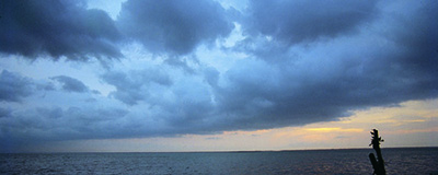
The bulk of air mass movement and transfer of solar heat energy occurs in the Hadley circulation cells located directly north and south of the equator. The sun warms the tropical ocean and causes evaporation of seawater into water vapor in the air. At the equator, hot air saturated with water vapor, a low-pressure system, rises and moves at a high altitude toward the North and South Poles. As the water vapor rises it forms clouds. This is why the tropics get a lot of rain (Fig. 3.11).
</p>")
Fig. 3.11. Clouds forming over the equator at the intertropical convergence zone.
Image courtesy of National Aeronautics and Space Administration (NASA)
The high-altitude air from the tropics gradually becomes cool, dry, and denser as it flows from the tropics to higher latitudes. Air begins to sink at about 30° north (N) and south (S), the northern and southern boundaries of the Hadley cells. This cool, dry sinking air creates a zone of high air pressure between 30° N and 40° N and 30° S and 40° S latitude. When it sinks, it splits; some air continues flowing along the earth’s surface to the poles, but most flows back toward the equator. The pressure difference between the sinking air at 30° N and S, a high-pressure zone, and the rising air along the equator, a low-pressure zone, is what drives the air back towards the equator, resulting in trade winds.
The trade wind belt blows towards the equator from the northeast in the Northern Hemisphere due to the combined effects of the Coriolis effect and the global north-south patterns of atmospheric circulation (Fig. 3.10).
At each pole, a cold polar air mass creates a region of high air pressure. The rotational speed of the polar air mass as it travels towards the equator is slower than the rotational speed of the land and water beneath it. The cold air mass cannot keep up with the rotating earth. Therefore, air flowing from the North Pole towards the equator produces cold, surface-level winds that blow from the northeast toward the southwest. These winds are called the polar easterlies. Winds are named by the direction from which they blow.
As the polar easterlies move toward the equator, they become warmer and less dense. At about 60В° N, part of the air mass rises and moves northward back towards the North Pole at high altitude, creating a band of low air pressure (Fig. 3.10). This circulation cell is called the polar cell. As with the Hadley cell, the difference in pressure between the poles and 60В° N latitude drives the wind circulation.
The Hadley cell distributes heat away from the equator, and the polar cell absorbs this heat. Hadley cell and polar cell circulation is straightforward as they are driven by the differential heating of the earth at the equator compared to the poles. This differential heating produces a relatively stable atmosphere and weather system. The Ferrel cell is located between the Hadley and polar circulation cells (Fig. 3.10). It can be found between 30В° N and 60В° N in the Northern Hemisphere and between 30В° S and 60В° S in the Southern Hemisphere.
Warm air rises at 60В° N at the southern edge of the polar easterly cell (Fig. 3.10). Air masses cool and sink at 30В° N at the northern edge of the trade wind cell. At 60В° N, part of the rising air mass goes north and part goes south. The sinking air mass also splits at 30В° N with part going north and part returning south. Thus, the Ferrel cell is like an atmospheric gear driven by the Hadley and polar circulation cells.
In the Ferrel cell in the Northern Hemisphere, the surface winds blow from the southwest and are called the prevailing westerlies. The prevailing westerlies blow from the southwest to the northeast because of the Coriolis effect—the air mass is moving faster than the rotational speed of the land and water beneath. Prevailing westerlies are the dominant winds blowing across most of the continental United States.
The areas where the circulation cells come together have no steady prevailing winds. At the intertropical convergence zone near the equator (Fig. 3.11), where the trade winds from the northern and southern hemispheres converge, the air rises, producing a belt of weak, light, shifting winds called the doldrums. The doldrums are an area of low pressure around the equator, where prevailing winds are calm. Because of the lack of winds in the doldrums, sailing vessels had a difficult time crossing the equator.
The horse latitudes are regions of light, variable winds where the Hadley and Ferrel circulation cells converge at 30° N and 30° S. Horse latitudes are typically in areas that are dry and warm, and many of the world’s largest deserts lie within this region. The term originates from a time when sailing ships could not make headway without steady wind, and the horses held aboard would die from lack of food and water. Another explanation is that sailors who were paid for part of their work before a voyage spent all of that pay at once, going into debt. This debt was called the “dead horse” time and was usually worked off by the time a ship from Europe reached the subtropics. Converging winds at 60° N and 60° S are much more unstable and do not tend to have windless periods.
The three-cell model (Fig. 3.10) of global atmospheric circulation is simplified. The actual global air distribution is much more complex. One of the reasons for this complexity is because water and land heat and cool differently. The amount of water and land area is different in the Northern and Southern Hemispheres. Another reason air currents are complex is that the locations of high- and low-pressure systems change dramatically with the seasons. In addition, high- and low-pressure systems do not typically form uniform bands, as described earlier. With the exception of 60В° S, where there is generally a low-pressure band around Antarctica, there are localized zones of high air pressure and low air pressure.
")


")


