
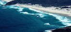
Fig. 5.2. Arial view of large surf zone in South Australia (Dog Fence Beach, western Eyre Peninsula)
Image courtesy of A D Short at OzCoasts
The coastline is the boundary between the ocean and the land. Approximately half of the worldвҖҷs population lives within 200 km of a coastline. Eight of the ten largest cities on Earth are located on the coast. Cities were built along the coast and waterways because people rely on the ocean to feed themselves and transport goods. In addition, for many the ocean is a source of inspiration, recreation, rejuvenation, and discovery.
Fig. 5.2. Arial view of large surf zone in South Australia (Dog Fence Beach, western Eyre Peninsula)
Image courtesy of A D Short at OzCoasts
The surf zone is the area near the coastline where waves break (Fig. 5.2). Surf is characterized by lines of foam formed by breaking waves and a distinctive, often rhythmic sound that many people find peaceful. Surf zones are found along the shores of the ocean as well as the shores of many large lakes. The location of breaking waves at a particular location depends on the depth of the water and wave characteristics like wave height, wavelength, and direction of wave movement. How a wave breaks depends not only on the steepness of the bottom slope but also on whether the bottom slope is smooth or irregular, whether the bottom is composed of shifting sands or solid rock, and even whether the water on the bottom is calm or moving.

Fig. 5.3. Diagram of the profile of a wave approaching shore; notice that the wave height increases as the water gets shallower.
Image by Byron Inouye
Surf usually contains a mixture of several types of breaking waves. As waves move into shallower water, they contact the bottom and begin to move slower (see the Wave Energy and Wave Changes with Depth topic in the Waves unit). As waves slow down, they get closer together; their wave period shortens. This process is called shoaling, and it causes the height of waves to increase (Fig. 5.3). The steeper the bottom slope, the greater the increase in wave height.
As a wave moves into increasingly shallow water, it continues to grow in height. Eventually, the wave will reach a height that causes it to break, or fall over onto itself. A wave may break more than once, and in different ways, as it advances to shore. As a wave advances, and each time it breaks, it loses energy. Larger waves tend to break in deeper water, farther from shore. Smaller waves tend to break in shallower water, closer to shore.
There are three types of breaking waves: plunging breakers, spilling breakers, and surging breakers. These three wave types are shown in Fig. 5.4. Combinations of each type of wave often occur in a surf zone.

Fig. 5.4. Three types of breaking waves include (A) plunging breakers, (B) spilling breakers, and (C) surging breakers.
Image by Byron Inouye
Plunging breakers (Fig. 5.4 A) form where there is a moderately steep, sloping bottom. Plunging waves form tubes or barrels that cascade water in a circular motion downward into the trough and break with a forceful crash, rapidly releasing energy. Air trapped inside the barrel of the wave may explode or spit out of the barrel as the wave races along. Water from colliding waves can also explode, forming geysers of white water as the wave breaks. If the bottom is very steep, a plunging wave becomes a collapsing wave, when the top of the wave breaks onto the lower part of the wave.
Spilling breakers (Fig. 5.4 B) form when the bottom slopes gradually. Spilling breakers form when fast-moving water at the top of a wave spills over slower-moving water at the bottom. Spilling waves advance to shore with a line of foam tumbling steadily down the front of the wave face. Unlike plunging waves, spilling waves break slowly over considerable distances. Spilling waves can offer long distance rides for surfers as the wave breaks toward shore.
Surging breakers (Fig. 5.4 C) form when large waves suddenly hit bottom in shallow water. Tsunami waves and tidal bores are examples of surging breakers. Tsunamis look like walls of white water advancing toward shore and can cause great damage when they run up the beach and onto land.
People can be found watching and riding waves worldwide, from Japan to Spain to Africa to the great lakes of North America. In general, a good surf spot is one that breaks fairly often and in a manner that offers rideable waves. Well known surf spots tend to have consistent waves, favorable weather, beneficial geographic orientation, and tidal fluctuations conducive to their geography. The map below shows some popular surf spots.
If the map does not display but requires you to log in your organization account, log out of your organization account in the browser, and then refresh this page.
Consistency
Waves are required in order to have surf. Wind speed, direction, and fetch all contribute to creating waves and swell. The consistency of surf is dependent on the consistency of global weather patterns. Popular surf destinations tend to be located in geographic regions that are in a position to be regularly impacted by swells.
Local Weather Conditions
Local weather does not often produce great surf because swells need time and space (fetch) to become organized. However, local weather does determine the conditions of waves that are produced by far-away storms. Locations with wind that typically blows offshore or side-shore are usually preferable to on-shore winds. This is because offshore winds help to hold the face of the wave up and open, to provide a smooth, surfable surface.
Geography
A surf spot needs to be exposed to waves in order to have surf, so exposure to predominant swell direction is important. In addition, the bottom contour has a dramatic effect on the shape of breaking waves. In general, if the bottom is very sloped, the resulting wave will be spilling. If the bottom is very steep, the resulting waves will be plunging. People like to surf both types of waves.
Four common types of surfing breaks include beach, point, reef, and river mouth:
Tides
Tides can dramatically affect the quality of surf because they influence both water motion and the relative depth of the bottom contour.

Fig. 5.6. In a reflected wave, the angle of incidence equals the angle of reflection for wave direction. The normal line is the horizontal dotted line. Arrows represent direction of incoming wave fronts.
Image by Matthew Lurie
Water waves exhibit the same behaviors as other waves, including electromagnetic and sound waves, when they encounter a boundary, such as an object. As water waves approach boundaries, their properties, including direction of propagation, speed, frequency, period, and energy, can change.
Reflection occurs when a water wave bounces off of a hard surface, such as a seawall or a seacliff, changing the direction of the wave. For reflected waves, the angle of incidence, the angle at which the wave approaches the surface, equals the angle of reflection. Both the angle of incidence and the angle of reflection are measured from a normal line, which is a hypothetical line perpendicular to the shoreline. For example, if a wave approaches a seawall at a 45 degree angle of incidence, the wave direction propagates away from the wall at a 45 degree angle of reflection (Fig. 5.6). The angle of incidence ranges from zero degrees, which is like a wave approaching a wall head on, to slightly greater than 90 degrees, which is like a wave approaching parallel to the wall. In general, the speed, frequency, period, and energy of a wave are not affected by reflection.

Fig. 5.7. As waves approach shallow water, they are refracted, changing the direction of the wave front, and their wavelength decreases. L1 is the wavelength of the incoming waves and L2 is the wavelength of the refracted waves.
Image by Byron Inouye
Refraction is the change in direction of waves as they move between materials with different properties. Water waves are refracted as they move from deep water to shallow water. Water waves travel faster in deep water than in shallow water. As water gets shallower and waves travel more slowly, their wavelength decreases. In Figure 5.7, L1 is the wavelength of the incoming waves and L2 is the wavelength of the refracted waves. As waves move from deep to shallow water, the wavelength decreases (L1 > L2). When this happens, waves change direction, moving toward the normal line, which is the line perpendicular to the boundary.

Fig. 5.8. Wave diffraction through an opening in a barrier. The wave fronts appear to bend around the edge of each of the barriers.
Image by Matthew Lurie
Waves come into shore and break parallel to the coast because ocean floor topography is generally similar to the shape of the beach. As waves approach the coast, they refract in shapes that mirror the coastline.
Diffraction occurs when waves pass through an opening or around a barrier and change direction (Fig. 5.8). The larger the wavelength and the smaller the barrier opening, the greater the waves will appear to bend around the barrier.
An aerial view of the coastline in Kihei, HawaiвҖҳi, shows reflection, refraction, and diffraction of water waves (Fig. 5.9 A). Wave sets coming from deeper waters refract as they come into shore, changing direction to match the shape of the coastline. A closer look at the Hawaiian fishpond, KoвҖҳieвҖҳie Loko IвҖҳa, shows diffraction, as the water moves through small openings in the pond, and reflection, as the waves bounce off of the retaining wall (Fig. 5.9 B). These and additional wave patterns are listed in Table 5.2.

Fig. 5.9. (A) Coastline of Kihei, HawaiвҖҳI, showing reflection, refraction, and diffraction of waves.
Image courtesy of Google Earth

Fig. 5.9. (B) Wave diffraction and reflection in KoвҖҳieвҖҳie Loko IвҖҳa fishpond.
Image courtesy of Google Earth
| Converging waves The higher waves formed when the crests of two waves merge; a wave interference pattern. |
| Diffracted waves Wave crests in a wave train that change direction, bending when going around a barrier or through an opening. |
| Parallel waves Sets of waves traveling together in the same direction with crests about equally distant from each other. |
| Radiating waves Sets of waves that move outward in concentric rings away from the generating source. |
| Reflected waves Waves that have bounced off an object. |
| Refracted waves Waves that change direction as they pass through different media, such as water of varying depths. |

Fig. 5.10. Wave refraction and diffraction cause converging wave fronts on headlands and diverging wave fronts in bays. This phenomenon concentrates wave energy on headlands and diffuses wave energy in bays.
Image by Byron Inouye
Refraction and diffraction affect the amount of wave energy reaching a coastline. For example, in bays, waves diverge due to refraction, reducing the relative amount of energy compared to a straight coastline. On the other hand, waves approaching a headland converge and concentrate energy, also due to refraction (Fig. 5.10). These differences in energy can affect the shape of the coastline. In general, bays will have more sedimentation, because they have less wave energy, and headlands will have more erosion, due to the higher amount of wave energy reaching them.
The energy of waves help to shape coastal features. Other physical processes, such as wind, tides, and storms can also shape the features of a beach. Coastal features are constantly changing; the same beach can look different over the span of a season or even a day. Common beach features are shown in Fig. 5.12 and described in Table 5.3.

Fig. 5.12. Profiles of typical coastal features, see Table 5.3 to identify the features marked with letters
Image by Byron Inouye
| Backshore The beach area between the foreshore and the foot of the dunes. This zone is between the shoreline and coastline. Normally the backshore is dry; waves only reach this area during storms. (H) |
| Bar (Sandbar) An embankment of sand, gravel, or other particles deposited in shallow water by waves and currents that are parallel to the shore. Bars may be submerged or emerged. There can be several rows of bars. (M) |
| Beach (Shore) Zone of loose sand, gravel, and other material that extends landward from the low tide waterline to the coastline. (B) |
| Beach Berm Long wedge of sand parallel to the shoreline that is normally in the backshore of the beach. Berms have different slopes on their seaward and landward sides; the steep side of a berm faces the ocean, the side that faces land has a more gentle slope or is flat. Beach berms are formed by waves depositing material. Berms can resemble terraces, with several beach berms on a beach. Or, a beach may have no berms. (J) |
| Breaker Zone Area where deep-water waves touch bottom and become shallow-water waves, changing from rounded swells to unstable, peaked waves that start to break. (K) |
| Coast A strip of land of indefinite width (up to several miles) extending from the coastline inland toward the first major change in land features that are not influenced by coastal processes. (A) |
| Coastline The line that forms the boundary between the coast (land) and the beach (shore). It is marked by the start of permanent vegetation or where there is a marked change in substrate or landform morphology (shape), for example, from a relatively flat beach to hilly dunes. (E) |
| Dunes Ridges or mounds of loose, windblown material, usually sand. Dunes are often vegetated, that is, they have plants growing on them. (G) |
| Foreshore That part of the beach (shore) between the water level at low tide and the upper limit of the wave wash at high tide (the shoreline). (I) |
| High tide The highest water level of each rising tide. (L) |
| Low tide The lowest water level of each falling tide. (N) |
| Nearshore The zone extending seaward from the water level at low tide (the foreshore) to beyond the breaker zone. This area is indefinite and is affected by nearshore currents. (C) |
| Offshore The direction seaward of the nearshore zone. (D) |
| Shoreline The line formed when the water touches the beach at high tide. The shoreline divides the beach into the foreshore and backshore. (F) |

Fig. 5.18. A sign warns beach goers at Hanauma Bay, OвҖҳahu, HawaiвҖҳi of the potentially strong longshore currents that flow parallel to shore.
Image by Kanesa Seraphin
Landforms and beach slope can be affected by waves. Landforms and beach slope can also affect waves, currents, and the movement of water. Longshore currents flow roughly parallel to the beach (Fig. 5.18). Rip currents are narrow, river-like currents that flow perpendicular to the coast, heading out to sea (Fig. 5.19). At the beach, a rip current usually begins where longshore currents collide and then flow together out to sea. A rip current can also form when water from an incoming high tide or from large waves flows over a bar or reef; the water then flows in a rip current back to sea through a gap or deep area in the bar or reef. Waves do not break as often in the gap where the rip current forms because the gap is deeper than the surrounding areas.

Fig. 5.19. Anatomy of a rip current, showing how currents parallel to shore intersect with the rip current heading out to sea
Image by Byron Inouye
A rip current is strongest at its neck, where the currents merge and flow back to sea through a deeper channel (Fig. 5.19). The strength and speed of a rip current dissipates as it heads out to sea, where the channel becomes wider or shallower. Waves are usually smaller, but choppier, in the area of a rip current. Because a rip current carries sediment out to sea, water in the rip current may appear a different color than the surrounding water (Fig. 5.20).
</p>")
Fig. 5.20. (A) A warning sign explains rip current dangers and how to avoid them.
Image courtesy of National Oceanic and Atmospheric Administration (NOAA)
</p>")
Fig. 5.20. (B) Multiple rip currents along the beach in Tunquen, Chili.
Image courtesy of Cecilia and Randy Lascody, from National Oceanic and Atmospheric Administration (NOAA)
The speed and energy of water in rip currents can be very dangerous. Over 100 people die each year in the U.S. in rip currents and they account for over 80% of rescues performed by surf beach lifeguards. In addition to observing and obeying signs and flags that warn about rip currents, and swimming at beaches with lifeguards, learn what a rip current looks like so you can avoid them (Fig. 5.21). If caught in a rip current, it is best to swim parallel to shore, until you are out of the rip current, before swimming toward shore.
</p>")
Fig. 5.21. (A) A warning sign explains rip current dangers and how to avoid them.
Image courtesy of National Oceanic and Atmospheric Administration (NOAA)

Fig. 5.21. (B) A sign at HaвҖҳena Beach Park, KauaвҖҳi, HawaiвҖҳI, warns swimmers that rip currents can sweep swimmers out to sea.
Image by Kanesa Seraphin
</p>")
Fig. 5.22. An eddy about 600 km off the coast of Australia in the southeastern Indian Ocean, which was made visible by a plankton bloom on December 30, 2013 that showed sea surface currents.
Image courtesy of Jesse Allen and Robert Simmon from NOAA, using data from Land Atmosphere Near real-time Capability for EOS (LANCE)
An eddy is a circular, whirlpool-like, movement of water (Fig. 5.22). Eddies typically spin off of larger ocean current systems; they can stretch for hundreds of miles and last for months. The interaction of longshore currents and eddy currents with coastal features produces stable, nearshore circulation patterns. Eddies can transport nutrients onshore, offshore, or from deep water, helping to maintain populations of plankton.
")


")


