
Geography: Made up of six groups of volcanic and raised coral islands, the Republic of Palau (also spelled Belau or Pelew) is located 400 miles east of the Philippines. Its 340 islands have a total land area of 193 square miles (Ridgell, 1995). Palau is the westernmost archipelago in the chain formerly known as the Caroline Islands, which includes Yap, Chuuk, Pohnpei, and Kosrae (the present day Federated States of Micronesia). All but six of Palau’s islands are enclosed in a large lagoon surrounded by a barrier reef, including the famous “rock islands” which number over 300 (Encyclopaedia Britannica, 2014i). A total of eight islands are inhabited: four volcanic/limestone islands and four outer islands (Central Intelligence Agency, 2014f).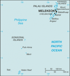
History: Somewhere between 2,000 to 3,000 years ago, Palau’s first inhabitants arrived from diverse locations, including Malays from Indonesia, Melanesians from New Guinea, people from the Philippines, and some Polynesians from outlying Polynesian islands in Micronesia (Encyclopaedia Britannica, 2014i). For about 100 years beginning in the late 1700s Palau had sporadic contact with shipwrecked Europeans and beachcombers as well as occasional visits from whalers and traders. In 1886 Spain formally claimed Palau (and the rest of the “Caroline Islands”) as a colony, although Spanish missionaries did not arrive until 1891 (Ridgell, 1995). At the conclusion of the Spanish-American war in 1899 Germany took possession of the islands, which it held until 1914. At the outbreak of World War I Japan moved to seize Germany’s colonial possessions in Micronesia, administering them under a mandate from the League of Nations (Encyclopaedia Britannica, 2014i). Fortified by Japan during World War II, Palau was the site of a famous World War II battle at Beliliou (Peleliu) which lasted for two months (Central Intelligence Agency, 2014f). In 1947, the United Nations created a strategic-area trusteeship encompassing more than 2,000 islands situated between 1° and 22° N latitude and 130° and 172° E longitude (an area of about 3 million square miles). Administered by the U.S., the U.N. Trust Territory of the Pacific Islands (TTPI) comprised the Marshall Islands, Palau, Yap, Chuuk, Pohnpei, Kosrae, and the Marianas islands (excluding Guam) (Encyclopaedia Britannica, 2014k). In 1981 a constitution and a presidential form of government were adopted. After more than a decade of unsuccessful attempts, the United States signed a Compact of Free Association (COFA) with Palau in 1993. In 1994 Palau became a sovereign nation (Encyclopaedia Britannica, 2014i).
Demographics: Palau’s population in 2014 is estimated to be approximately 21,000 (Central Intelligence Agency, 2014f). The main population centers are located on the islands of Babelthuap (Babeldaob) & Koror. Koror city, the largest city in the country, was the capital until 2006 when the seat of government was moved to Melekeok on Babelthuap, where the international airport is located (Encyclopaedia Britannica, 2014i). Approximately 39% of the population are foreign nationals (Wasem, 2004), largely from the Philipines and Taiwan. Palau has three official languages: Palauan, Sonsorolese-Tobian, and English. Palauan is spoken by approximately two-thirds of the population; Sonsorolese-Tobian is limited to Sonsorol Island in the southwest. To this day Palau is a strong matrilineal society, with women controlling land, money, and titles. Christianity is the major religion on Palau. Approximately half of the population is Roman Catholic and a quarter is protestant. Palau has a near total literacy rate. Palauans tend to emigrate more than residents of other Pacific Island countries, and there are significant communities of Palauans in Guam, Hawaiʻi, and the U.S. west coast (Encyclopaedia Britannica, 2014i).
 Economy: Since World War II, most people on Palau have worked for the government. Some people engage in near-shore fishing and subsistence farming of taro, sweet potato, and cassava. Palau has no major export crops (Central Intelligence Agency, 2014f). The Palauan government generates some revenue through licensing foreign commercial tuna fishing vessels. In addition to tuna, Palau exports a small amount of clothing (Encyclopaedia Britannica, 2014i). Expansion of air travel in the Pacific and Palau’s proximity to Guam, a major destination for East Asian tourists, has caused rapid growth in its tourism industry. Revenues from tourism together with significant U.S. Government aid received under the COFA are two reasons why the population has a per capita income roughly double that of the Philippines and much of Micronesia. Major imports include machinery and equipment, fuels, metals, and foodstuffs (Central Intelligence Agency, 2014f).
Political Affiliation: Palau is an independent country (Wasem, 2004). Since 1981 Palau has had internal self-government, while under the COFA the United States is responsible for external security (Encyclopaedia Britannica, 2014i). In exchange for defense and foreign aid, the COFA entitles the U.S. government to unfettered access to Palau’s land and waterways for strategic purposes (Central Intelligence Agency, 2014f). Palauan nationals are not U.S. citizens, although they may freely migrate to the U.S. under the terms of the COFA (Wasem, 2004).