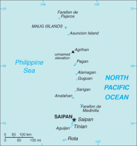
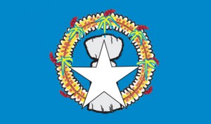
Geography: The Northern Mariana Islands are a group of 14 volcanic and raised coral islands (Ridgell, 1995) located about three-quarters of the way from Hawaiʻi to the Philippines. The islands have a total land area of 179 square miles (Central Intelligence Agency, 2014e). Located about 1,000 miles south of Japan, the island chain spans 375 miles. Guam, the southernmost island in the Marianas chain, is a separate political entity (Ridgell, 1995).
History: The original inhabitants of the Mariana Islands were Micronesians who arrived there between 3,000 and 4,000 years ago (Ridgell, 1995). Some archaeological evidence such as pottery similar to the style of Philippine ceramics suggests that these people may have originated in Southeast Asia (Encyclopaedia Britannica, 2014h). These native people, called Chamorros, carved large stone pillars arranged in parallel rows as structural supports for buildings. Called latte stones, these pillars are prevalent in Guam and the Northern Mariana Islands. Found only in the Marianas, latte can reach up to 16 feet in height. After Ferdinand Magellan’s brief stop at Guam in 1521, Spain declared the Marianas a colony in 1565, although there was no permanent settlement there until the arrival of Jesuit priests in 1668. The Jesuit priest Diego Luis de Sanvitores named the islands after the regent of Spain, Mariana of Austria, who had financed his mission. Conflicts erupted between native Chamorros and the Spanish settlers, leading to the Spanish Chamorro wars of 1680 to 1696 (Encyclopaedia Britannica, 2014h). During these wars the people of Saipan and Rota in the Northern Marianas were forcibly relocated to Guam by the Spanish (Ridgell, 1995). During this period the indigenous Chamorro population was also severely depleted as a result of diseases introduced by the Spanish. At the culmination of the wars, the Chamorro people were forced to swear an oath of allegiance to the king of Spain and adopt western dress and customs. At the end of the Spanish-American war in 1899, Germany purchased the Northern Mariana Islands while America retained possession of occupied Guam (Hezel, 2003). Interested in developing Copra for export, the Germans held the islands until the outbreak of World War I, when they were seized by Japan (Encyclopaedia Britannica, 2014h). The Japanese introduced extensive sugar cultivation to the islands. Many Japanese citizens were living in the islands at the outbreak of World War II, and Japan immediately captured Guam from the Americans. In June and July of 1944 the U.S. took Saipan from the Japanese in one of the bloodiest battles of the war (Ridgell, 1995). In 1947, the United Nations created a strategic-area trusteeship encompassing more than 2,000 islands situated between 1° and 22° N latitude and 130° and 172° E longitude (an area of about 3 million square miles). Administered by the U.S., the U.N. Trust Territory of the Pacific Islands (TTPI) comprised the Marshall Islands, Palau, Yap, Chuuk, Pohnpei, Kosrae, and the Mariana Islands (excluding Guam) (Encyclopaedia Britannica, 2014k). In 1975 the people of the Northern Mariana Islands voted to become a commonwealth in association with the United States (Encyclopaedia Britannica, 2014h).
Demographics: Most residents of CNMI live in the capital, Saipan, which together with the islands of Tinian and Rota comprise the primary population centers. Other inhabited islands include Anatahan, Alamagan, and Agrihan (Ridgell, 1995). Chamorro and English are the official languages, spoken by 24% and 17% of the population, respectively. Philippine languages are spoken by 33% of the population, with the remainder speaking other Pacific Island languages (10%), Chinese (7%), and other Asian languages (7%) (Central Intelligence Agency, 2014e). Over time the original Chamorro inhabitants of the islands mixed with Spanish, Mexican, and Filipino peoples; today their descendants make up about one-fifth of the population of the islands. About one quarter of the population is Chinese and another quarter are Filipino; the remainder are made up of Micronesian people who immigrated from Palau, Yap, Chuuk, Pohnpei, and Kosrae in the nineteenth and early twentieth centuries (Encyclopaedia Britannica, 2014h).
 Economy: Approximately one quarter of the country’s GDP and one quarter of its workforce are employed in the tourism industry (Central Intelligence Agency, 2014e). Most tourists come from Japan, Korea, or America and go to Saipan or Rota (Encyclopaedia Britannica, 2014h). The garment industry is also a major source of exports. Until recently the country was exempt from many of the wage and labor regulations of the U.S. while still not being subject to duties and quotas imposed on foreign producers. This led to allegations of poor working conditions and labor practices, leading the U.S. government to enact minimum-wage and other legislation in 2007. As a result of this legislation (and infrastructure destruction from 2010 typhoons), production of garments and textiles has declined in recent years. Another major source of revenue is financial aid from the U.S. government. Small-scale agriculture operations produce coconuts, breadfruit, tomatoes, and melons; there are also several cattle ranches. The country relies on imports for food, construction equipment and materials, and petroleum products (Central Intelligence Agency, 2014e).
Political Affiliation: The Commonwealth of the Northern Mariana Islands enjoys a political union with the U.S. administered by the U.S. Department of the Interior, Office of Insular Affairs. The commonwealth is self-governing and has a locally-elected governor, lieutenant governor, and legislature (Central Intelligence Agency, 2014e). When the full commonwealth status of the Northern Marianas Islands went into effect upon the dissolution of the TTPI in 1986, eligible residents of the islands became U.S. citizens (Encyclopaedia Britannica, 2014h). The Commonwealth has a non-voting delegate to the U.S. House of Representatives (Wasem, 2004).


