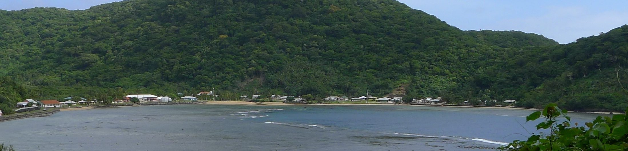
Geography: American Samoa consists of 7 volcanic islands and coral atolls in the western half of the Samoan Archipelago. Located in Polynesia in the south-central Pacific, American Samoa is approximately 1,600 miles northeast of New Zealand and 2,200 miles southwest of Hawaiʻi (Encyclopaedia Britannica, 2014a). American Samoa has a total land area of 76 square miles, 52 of which comprise the main island of Tutuila. Other inhabited islands include nearby Aunu‘u, Swain Island atoll to the north, and the three islands of the Manu’a group: Tau, Olosega, and Ofu, which are located about 62 miles east of Tutuila. The lone uninhabited island of American Samoa is Rose atoll, located far to the east of Tutuila (Ridgell, 1995).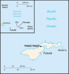
History: The first settlers of the Samoan islands were Polynesian voyagers who arrived around 1,000 B.CE, most likely from Tonga. It is from Samoa that these same Polynesian voyagers are thought to have departed to settle much of eastern Polynesia, starting around 500 C.E. First contact with Europeans came in 1722, when the islands were sighted by the Dutch explorer Jacob Roggeveen. Sporadic contact with traders, beachcombers, and other European navigators followed. In the 1830s the first missionaries arrived at Tutuila, sent by the London Missionary society (Encyclopaedia Britannica, 2014a). Traditionally, Tutuila was a haven for chiefs exiled from the main Samoan islands of Savai’i and ‘Upolu to the west. The Manu’a islands were politically independent and had their own high chief (Ridgell, 1995). This changed in the late 1800s. Pago Pago has one of the best natural deep-water harbors in the South Pacific (Central Intelligence Agency, 2014a), leading the U.S., Germany, and Great Britain to vie for control of the Samoan Islands throughout the late 1800s. Eventually Great Britain withdrew its claim (Ridgell, 1995), and the U.S. signed a treaty for the establishment of a naval station at Pago Pago harbor in 1878. Without any input from the local chiefs, the U.S. and Germany unilaterally agreed in 1899 to divide the islands into eastern (now American) Samoa and Western Samoa (now Samoa). By 1904 the local chiefs had formally ceded all of the eastern islands to the United States, although congress did not formally accept the deeds of cession until 1929. From 1900-1951 the U.S. Navy exercised control over American Samoa; in 1951 control was transferred to the Department of the Interior, and a territorial governor with full powers to administer the territory was appointed. Demands from Samoans for a higher degree of self-rule led to the first gubernatorial election in 1977; since then all governors have been elected by the people. In 1981 American Samoa sent its first non-voting delegate to the U.S. Congress. In 2009 an undersea earthquake near Samoa generated a tsunami which caused extensive damage and flooding, especially on Tutuila (Encyclopaedia Britannica, 2014a), killing around 200 people (Central Intelligence Agency, 2014a).
Demographics: Most Samoans are bilingual in the Samoan language and English (Encyclopaedia Britannica, 2014a). Both are official languages. The population as of July 2014 is estimated to be approximately 54,500. Almost the entire population is Christian, a mixture of Christian Congregationalist (50%), Roman Catholic (20%), and Protestant and other denominations (30%) (Central Intelligence Agency, 2014a). The majority of the population (90%) is ethnic Samoan, with the remainder made up of Tongan, Asian, and European people (Encyclopaedia Britannica, 2014a). Over 40% of the population is foreign-born. Most come from Samoa, but there are also people from Tonga and other Pacific islands, the United States, and various Asian Countries (Encyclopaedia Britannica, 2014a). Samoan society is based around extended families (aiga) which are headed by communally-selected chiefs (matai). District councils (fono) made up of a group of matai control and run local affairs. The majority of Samoans live in coastal villages, with the exception of Pago Pago, the lone urban area (Encyclopaedia Britannica, 2014a).
 Economy: The Samoan economy is strongly linked with the U.S. (Central Intelligence Agency, 2014a). Government jobs are the main source of employment (Encyclopaedia Britannica, 2014a). Canned tuna is American Samoa’s main export, and there are a number of fishing, processing, and cannery operations in American Samoa. Just two canneries account for 80% of the territory’s non-government employment. Tourism is developing but limited at present. The rest of the economy is organized in traditional Polynesian fashion, with more than 90% of the land communally owned (Central Intelligence Agency, 2014a), and family gardens producing coconuts, breadfruit, and yams. Taro, bananas, tropical fruits, and some vegetables are produced on a semi-commercial basis (Encyclopaedia Britannica, 2014a).
Political Affiliation: American Samoa is a U.S. Territory administered by the U.S. Department of Interior. Because it is an unincorporated territory, not all provisions of the U.S. Constitution apply there (Wasem, 2004). For example, residents of American Samoa cannot vote in U.S. presidential elections, although they may vote in democratic or republican primary elections (Central Intelligence Agency, 2014a). American Samoa has one non-voting delegate to the U.S. House of Representatives (Wasem, 2004). American Samoa is an unorganized territory, meaning that authority for its governance is under the U.S. Secretary of the Interior, who authorized the territory to draft its own constitution in 1967 (Encyclopaedia Britannica, 2014a). The people of American Samoa are U.S. nationals but not U.S. citizens.