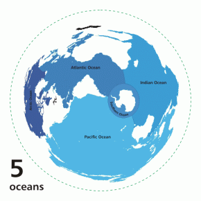
Some ideas that categorize the world, such as the number of ocean basins, can seem like unchanging facts. But really, these categories are based on human definitions and can be modified over time with new information. As exploration and improvements in methodology add to the body of scientific knowledge, prevailing scientific ideas can, and do, change. The Southern ocean basin is one example of how politics and human nature interface with science.
Some maps have a fifth ocean basin called the Southern ocean basin, which comprises the area surrounding Antarctica, including the southern portions of the Indian, Atlantic, and Pacific ocean basins. Unlike other ocean basins, which are enclosed by land and have depressions in their center, the Southern ocean basin has a continent at its center and no northern land boundary. Because of this difference, the Southern ocean basin was not standardized on historical maps.
SF Fig. 1.1. Although there is one world ocean, there are disagreements over the number of ocean basins. This series of maps shows the world ocean divided into one, three, four, and five ocean basins. Note that the maps have been distorted to show more of the world than a typical view from the South Pole. Click on the image for animation!
In recent times, however, oceanographic research has shown that the water in the area around Antarctica is very different from the water in the other ocean basins. The current that flows around Antarctica, the Antarctic Circumpolar Current, circulates around Antarctica rapidly so that water in the Southern ocean basin south of South America is more similar to water in the Southern ocean basin south of New Zealand than to water in the Atlantic or Pacific ocean basins. This, as well as the discovery of the formation of distinctive cold, dense water around Antarctica, has lead to renewed interest in standardizing the Southern ocean basinŌĆÖs northern boundary on maps.
Exploring Our Fluid Earth does not include the Southern ocean basin in investigations of the worldŌĆÖs ocean basins because the Southern ocean basin is not a true basin, or depression, in the earthŌĆÖs crust. If countries include the Southern ocean basin on their maps, most denote its northern boundary at 60┬░S, the upper limit of the Antarctic Circumpolar Current (see SF Fig. 1.1). However, since there is no internationally recognized boundary, countries are free to denote the boundary differently. For example, Australian maps show the Southern ocean basin extending up to the Australian southern coast (about 35┬░S latitude).
Similar to the Antarctic, the Arctic ocean basin also has some controversy over its designation. Exploring Our Fluid Earth includes the Arctic ocean basin in investigations of the worldŌĆÖs ocean basins because the Arctic ocean basin is a true basin. However, some oceanographers consider the Arctic ocean basin to be a sea within the Atlantic ocean basin rather than a basin of its own. This is because the Arctic ocean basin is shallow compared to other basins, is almost completely surrounded by land, has only limited water exchange with other basins.


