</p>")
Fig. 3.2. This weather map illustrates high pressure (H) and low pressure (L) weather systems across North America.
Image courtesy of National Oceanic and Atmospheric Administration (NOAA)
The atmosphere of the Earth is a layer of gases that make up the air, and it is in constant motion. The atmosphere is generally densest when it is close to earth and decreases in density as altitude increases. Gradients in the earth’s atmosphere create areas of differing temperature and moisture content that are known as air masses. An air mass is any volume of air that moves about the earth and can vary greatly in size. An air mass may be large enough to cover an entire continent while a small air mass might only cover a single building. An air mass can be described by properties such as its density, temperature, pressure, and movement. Winds are currents of air that move across the earth’s surface and develop when two adjacent air masses have different densities. The movement of air masses above the earth’s surface helps to create wind, and help to move the air masses that predict our weather. The wind helps to shape the atmosphere and affects weather patterns from the upper atmosphere to the ocean surface.
Fig. 3.2. This weather map illustrates high pressure (H) and low pressure (L) weather systems across North America.
Image courtesy of National Oceanic and Atmospheric Administration (NOAA)
Air has weight and is pulled towards the surface of the earth by gravity. The weight of an air mass pushes down on the surface of the earth creating pressure. Pressure is a force exerted over an area, and local pressure gradients can have an effect on weather. Atmospheric pressure is the force of an air mass on the earth’s surface. Recall that when two different air masses have different densities, wind currents are produced. Atmospheric pressure density drives our wind currents and more dense air produces greater pressure then less dense air. Differences in these pressure gradients can be visualized using satellites and are used to forecast weather. The “H” on weather maps identifies regions that are under air masses exerting relatively high atmospheric pressure (Fig. 3.2). The “L” identifies regions under air masses exerting relatively low atmospheric pressure compared to the high-pressure regions around it.
Two things affect air density, and thus air pressure: the temperature of the air and the amount of water vapor in the air. Warm air is less dense than cold air. Water vapor—water that has evaporated into a gaseous phase—decreases the density of an air mass. This is because water vapor is less dense than the other common gases in air. At the same temperature, dry air exerts a greater force than moist air. Therefore dry, dense air masses produce high-pressure areas; moist, less-dense air masses produce low-pressure areas. The formation of rain, snow, and dew removes water vapor from an air mass, leaving dryer, less dense air.

Fig. 3.3. An atmospheric convection current forms when dense cold air sinks and less dense warm air rises. Cold air shown on the left of the diagram moves in and replaces warm air that has risen.
Image by Byron Inouye
Differences in air pressure can result in the movement of air masses from one location to another. Air masses tend to flow from areas of high air pressure to areas of low air pressure. Thus, winds blow away from high-pressure areas; wind blows towards low-pressure areas.
Air masses also move vertically. Dense, cold air masses sink and push less dense warm air masses upward. Movement caused by differences in temperature produce convection currents (Fig. 3.3). As warm air rises, it becomes less dense, spreads out, and cools.

Fig. 3.4. Water vapor is produced as water evaporates from a boiling lake in Yellowstone National Park.
Image courtesy of Brocken Inaglory, Wikimedia Commons
Evaporation is the physical change of a liquid into a gas. Liquid water can evaporate into water vapor in the atmosphere. Water vapor is the gaseous phase of water and is invisible. Water can evaporate from the ocean, lakes, soil, plants, and even animals. Liquid water can also change into water vapor when it is heated to its boiling point (Fig. 3.4). Boiling a pot of water on a stove is an example of changing liquid water into gaseous water vapor.
Warm moist air masses rise. Air masses cool as they move upward. When moist air masses begin to cool, water vapor begins to condense. Condensation is the physical change of a gas into a liquid. Water vapor can condense to form small water droplets visible as clouds in Earth’s atmosphere.
Within a cloud there is a balance between water vapor condensing to form drop liquid water droplets and liquid water droplets evaporating to form water vapor. This process can be seen in the changing shapes of clouds. If condensation exceeds evaporation, precipitation tends to occur. Precipitation is the fall of water—in any shape or form—from the atmosphere to the earth’s surface. Examples of precipitation include rain, snow, sleet, and hail.
The temperature of an air mass determines how much water vapor the air can hold. Humidity is a measure of the amount of water vapor in the air and is reported as the percentage of the maximum amount of water vapor that air can carry at a particular temperature. At 100 percent humidity, air is has reached its water vapor capacity and can carry no more. The water vapor molecules clump together when humidity is at 100 percent, and liquid water is produced. We often see this occur as rain, or precipitation.
Mountains can force approaching air masses to rise to higher elevations. As the altitude of the air mass increases, the air expands because the air pressure is lower at higher elevations. When this happens, the volume of the air mass increases and the density decreases. At the same time, the temperature of the air mass decreases, causing water vapor in the air mass to condense and form clouds, and often precipitation. Orographic precipitation is the fall of water on the side of the mountain range facing the direction of approaching air masses (Fig. 3.5 A). This mountain face is the upwind, or windward, side and is often green with vegetation. This phenomenon captures precipitation on one side of a mountain range, while leaving the other side of the mountain dry. A rain shadow is a dry area that forms on the downwind or leeward side of the mountain (Fig. 3.5 B). The Mojave and Great Basin Deserts in the southwestern United States are both located in the large rain shadow cast by the Sierra Nevada mountain range.

Fig. 3.5. (A) As warm, humid air masses are pushed up over mountains, they cool and form orographic clouds that release precipitation.
Image courtesy of Thebiologyprimer, Wikimedia Commons
, <a data-cke-saved-href=\"https://www.climate.gov/sites/default/files/CW_hawaii_crop_highRes_0.jpg\" href=\"https://www.climate.gov/sites/default/files/CW_hawaii_crop_highRes_0.jpg\" target=\"_blank\">Climate.gov</a></p>")
Fig. 3.5. (B) Orographic clouds form over the east facing, or windward, side of the Kohala mountain on the island of HawaiК»i, leaving the west facing leeward side of the mountain in a rain shadow.
Image courtesy of National Oceanic and Atmospheric Administration (NOAA), Climate.gov
The two main factors affecting wind patterns are 1) the heat distribution between the earth’s equator and poles, and 2) the constant rotation of the planet. The sun is Earth’s primary energy source. However, energy from sunlight is not evenly distributed over the earth’s surface. The sun’s rays are most direct at the equator, which means the ocean and air near the equator receives the most solar energy. The sun’s rays are much less direct at higher latitudes away from the equator, such as the polar areas (Fig. 3.6).

Fig. 3.6. The tilt of the earth causes uneven heating from the sun throughout the year. Image not drawn to scale.
Image by Byron Inouye

Fig. 3.7. Hypothetical simplified atmospheric circulation between the equator and poles if the earth did not rotate. Hot, moist, less-dense air masses rise at the equator and becoming cold, dry, and more dense before sinking at the poles.
Image by Byron Inouye
Over a year, about 60 times more sunlight falls on equatorial areas than on polar areas. This is due to the tilt of the earth on its axis (23.4В° from vertical; Fig. 3.6). The north and south poles only have sunlight during their summer months. Even in the summer, light is spread over a wider area at the poles than at the equator, reducing the intensity of light and heat. Consequently, hot equatorial air masses, which are often humid, are less dense than cold polar air masses, which are often dry.
At the poles, air masses sink as they become colder and denser. These sinking air masses push or displace other air masses away as they flow along the ground towards the equator (Fig. 3.7). Polar air becomes warmer as it moves away from the poles. Air masses at the equator move in the opposite manner. At the equator, hot, moist, and less-dense air rises. At higher altitudes, this air gradually cools, forming precipitation, and dries out as it moves away from the equator and toward the poles. The sinking of polar air and rising of equatorial air form a large-scale global circulation pattern and explains why winds generally travel from north to south in the Northern hemisphere (Fig. 3.7). Unequal heating of the earth affects pressure and density, and assists in driving wind flow patterns.
The earth constantly rotates, or spins, on its axis counter-clockwise, from the west towards the east. The earth has a greater circumference at the equator than near the poles, so in one rotation, a point on the equator will cover a greater distance than a point near the poles, in the same amount of time. This means land and water near the poles is traveling from west to east at a few kilometers an hour, but land and water at the equator is moving in the same direction at more than two thousand kilometers an hour.
The atmosphere surrounding the earth rotates at the same speed as the land and the ocean surface beneath it because air masses are loosely attached to the earth's surface by gravity. Air masses near the equator are moving at a rate of 465 meters per second (m/s). Air masses located about 50 kilometers south of the North Pole are moving at a rate of 7.50 m/s. The differential rotation of the higher latitudes compared to the equator affects the movement of air masses and water on earth.

Fig. 3.8. As the earth rotates, points on the equator move at a greater rotational velocity than points near the north or south pole. An air mass flowing from the North Pole to the equator (shown in green) is deflected to its right in the Northern Hemisphere, due to the rotation of the earth.
Image by Byron Inouye
Warm, dense, high-pressure air masses tend to flow away from the equator towards cool, less dense, low-pressure air masses at the poles. However, air masses do not move north or south in a direct, straightforward line due to the rotation of the earth and the Coriolis effect. The Coriolis effect is the deflection of air and water masses by the rotation of the earth. Differences in rotational velocity between air masses located near the equator and those located near the poles deflect air circulation to the right in the Northern Hemisphere (Fig. 3.8) and to the left in the Southern Hemisphere. This deflective force of the Coriolis effect is greatest near the poles and weakest at the equator. The Coriolis effect operates over a period of weeks because the movement of air masses is relatively slow.
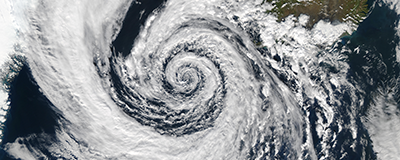
The Coriolis effect determines the movement of large-scale winds as well as localized high- and low-pressure systems. For example, in the Northern Hemisphere, the movement of air masses is deflected to the right as they approach low-pressure systems (Fig. 3.8). This deflection causes the low-pressure systems, like hurricanes, to spiral counter-clockwise in the Northern Hemisphere (Fig. 3.9 A). Low-pressure systems spiral clockwise in the Southern Hemisphere because air mass movement is deflected to the left (Fig. 3.9 B).
</p>")
Fig. 3.9. (A) A low-pressure system spiraling counter-clockwise over Iceland in the Northern Hemisphere.
Image courtesy of National Aeronautics and Space Administration (NASA)
</p>")
Fig. 3.9. (B) A low-pressure system spiraling clockwise over Australia in the Southern Hemisphere.
Image courtesy of National Aeronautics and Space Administration (NASA)
")


")


