Russian ship finds tsunami debris where UH Mānoa scientists predicted
University of Hawaiʻi at MānoaContact:
Posted: Oct 14, 2011
Ever since the great Japan tsunami on March 11, 2011, washed millions of tons of debris into the Pacific, scientists at the University of Hawai‘i at Mānoa’s International Pacific Research Center have been trying to track the trajectory of this debris that can threaten small ships and coastlines. For nearly half a year, senior researcher Nikolai Maximenko and scientific computer programmer Jan Hafner had only their state-of-the-art – but still untested – computer model of currents to speculate where the debris might end up. Now valuable sightings of the debris are reported from places where the model predicted.
Warned by maps of the scientists’ model, the Russian sail training ship, the STS Pallada, recently found an array of unmistakable tsunami debris on its homeward voyage from Honolulu to Vladivostok.
Soon after passing Midway Islands, Pallada spotted surprising number of floating items. “On September 22, in position 31042,21 N and 174045,21 E, we picked up on board the Japanese fishing boat. Radioactivity level – normal, we’ve measured it with the Geiger counter,” wrote Natalia Borodina, information and education mate of the Pallada. “At the approaches to the mentioned position (maybe 10 – 15 minutes before) we also sighted a TV set, fridge and a couple of other home appliances.”
Borodina adds on September 27 that “we keep sighting everyday things like wooden boards, plastic bottles, buoys from fishing nets (small and big ones), an object resembling wash basin, drums, boots, other wastes. All these objects are floating by the ship.”
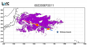
The map shows the stretch of Pallada’s route where debris was sighted between September 21 and 28, 2011. The red rhombus marks the location where the Japanese boat was found, and the red circle denotes maximum debris density experienced. Purple color shows the distribution of the tsunami debris in the SCUD model on September 25.
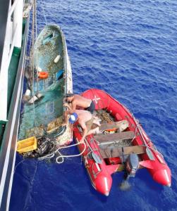
On October 8, the Pallada entered the port of Vladivostok. The most remarkable photo taken of the voyage is of a small fishing vessel about 20 feet long, which they were able to hoist up on to the Pallada. The markings on the wheel house of the boat show its home port to be in the Fukushima Prefecture, the area hardest hit by the tsunami.
With the exact locations of some of the by now widely scattered debris, scientists can make more accurate projections about when the debris might arrive at the Papahanaumokuakea Marine National Monument. The first landfall on Midway Islands is anticipated this winter. The debris that misses Midway will continue toward the main Hawaiian Islands and the North American West Coast.
Researcher Contact:
Nikolai Maximenko: Phone (808) 956-2584; email: maximenk@hawaii.edu
Jan Hafner: Phone (808) 956-2530; email jhafner@hawaii.edu
STS Pallada Contact: Natalia V. Borodina: email sts_pallada@email.ru
Photo captions:
Photo 1: The Pallada. Image courtesy of the Pallada.
Photo 2: Map of Pallada’s route through model projection of debris as of September 25. Image courtesy of Nikolai Maximenko and Jan Hafner.
Photo 3: Hoisting up to Pallada the Japanese boat registered to Fukushima Prefecture and, presumably, washed into the ocean during the March 11, 2011 tsunami. Image courtesy of the Pallada.


