Orientation to the Affected ‘Āina
Before foreign minds conceived the H-3, the corresponding landscape was imbued with spiritual, familial, and cultural significance. We highlight some events that lend to such significance of the local geography, referring to them as “Kanaka Processes” on our H-3 timeline. While not of the same bureaucratic yolk as many of the Western processes that we include (judicial, legislative, regulatory, etc.), the Kanaka processes hold immense significance in the Native Hawaiian perspective.
For Kānaka, the conventional notion of utilizing maps as a means to comprehend and traverse the world holds no pre-colonial significance. Instead, sense of place was crafted through references called performance cartographies. These encompass the likes of inoa ʻāina (place names) and land demarcations such as ʻili, ahupuaʻa, and moku.[1]
While these mechanisms resemble maps in their intricate portrayal of spatial cognition and distinctive characteristics, their foundation is deeply rooted in oral traditions.[2] Analogous to numerous Indigenous counterparts, Kanaka perceptions of reality intertwine cosmology, genealogy, historical narratives, and lived encounters, elegantly weaving them into an oral tapestry that gracefully unfurls across the physical terrain.[3]
Holding this Kanaka epistemology in one hand and a Western one in the other, we will explore four primary divisions of land in this research, and their inoa ʻāina are: Moanalua, Luluku, Haʻikū, and Hālawa.
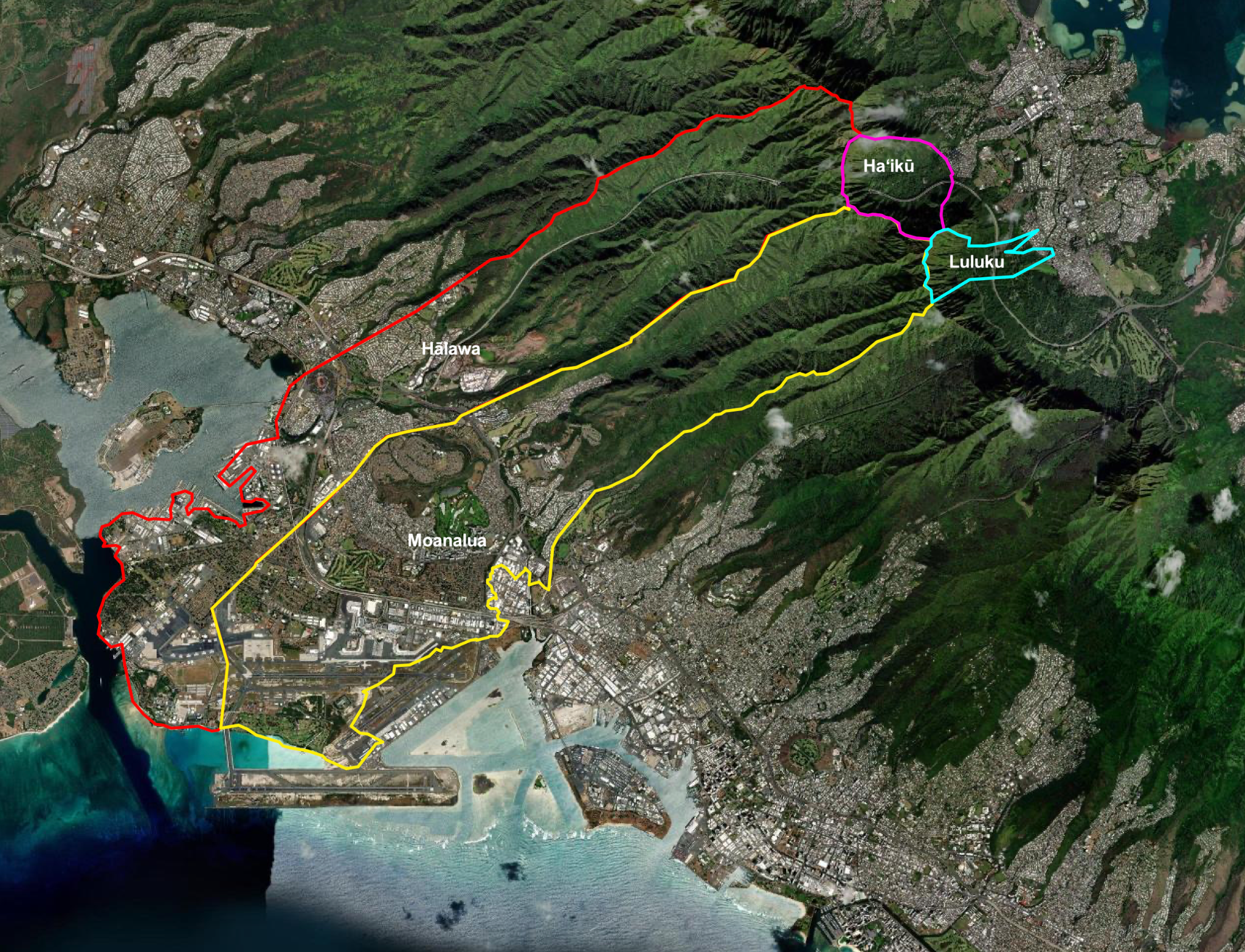
The H-3 freeway is a 16-mile (26 km) highway that connects Pearl Harbor on the south side of Oʻahu to the Marine Corps Base Hawaii on the east coast. Although it is now a major transportation artery on Oʻahu, providing more vehicle access between the windward and leeward sides of the island, it was controversial from the start. Kānaka ʻŌiwi largely opposed the freeway’s construction, arguing that it would damage the cultural landscape, disrupt their ancestral connections to the land, and harm the environment. Despite the controversy, the H-3 freeway was ultimately authorized in 1960. Construction began in 1989, costing over $1 billion, and it was completed in 1997.
Much of the lower portion of Moanalua Ahupua‘a has been heavily modified by the urbanization and militarization of Honolulu. The upper half of this ahupua‘a remains undeveloped, with three main streams that flow down through the two main valleys, eventually merging together just mauka of the Moanalua Freeway. Moanalua has an extremely rich cultural and historical heritage, including references to mythical pueo from the outer islands who used to meet in Moanalua to do battle; kōlea, who would travel overhead every night to count the number of people; a famous lava tube running from the windward side of the island (at Ka‘a‘awa) that opened up somewhere in Moanalua and was said to contain “many creeks, rivers and streams; and famous pūnāwai and lo‘i kalo. Within the National Historic Register inventory, specific areas were mentioned as having historical significance.
Moanalua encompasses the valleys of Kamananui and Kamanaiki. The water of these valleys Waiololi and Waiolalo, were spoken of in the Hawaiian creation chant of Kumulipo. Many legends of these places speak to the activities of the Hawaiian creator gods in the making of life. Other areas deemed sacred were the Ualuahine (Pōhaku ka luahine) petroglyph rock at Kahaukomo, the spring of Iemi, and the Umi Mua heiau (temple). The area of Mailehahei overlooked other historical sites such as Keʻehi Lagoon and Kamanaiki, the ʻāina eʻepa of the menehune.[4] In the 1600s, Kakuhihewa, high chief of Oʻahu, designated Moanalua valley as the center of hula and chanting.[5]
Originally, the H-3 freeway was supposed to cut through Moanalua, but after a long legal battle at the U.S. Supreme Court, Moanalua was given legal historical protection, largely in part due to Pōhaku Ka Luahine. The largest freestanding petroglyph boulder on Oʻahu, it contains depictions of human figures and a konane board.[6] A location for presenting offerings that connected the mundane to the divine,[7] it is located at the head of Moanalua Valley by the side of the stream on the land known as Kahalelauki and measures 11 by 8.7 feet by 3 feet high.[8] Pōhaku ka Luahine exists as an akua with at least two forms; as a stone it was known as Laupo, and as a bird it was known as Laea.[9] Oral history tells us that the boulder received its name because of a child who began crying during a kapu ceremony, and to save the child from death the mother hid with them by this stone.[10]
In the next ahupuaʻa, as we follow the H-3 freeway, we arrive at the ʻili of Luluku in the ahupuaʻa of Kāneʻohe, where we find Kukuiokāne heiau “inland from Heeia at the foot of the ridge [Keahiakahoe] above the banana fields.” This heiau was the largest and most important one in the region. From 1400-1500 A.D., Kukuiokāne heiau is said to be built when Oʻahu was unified under control of chiefs Kakuhihewa, Olopana, Kamapuaʻa and Kalamakua, a time when large temples were built.[11] Kukuiokane was dedicated to Kāne, the god of water and farming. American pineapple businessmen destroyed it so that they could make a profit off of the area by growing pineapples. This effort failed, however, as their pineapples were attacked by a disease that left the businessmen looking elsewhere for land to use. According to accounts, the structure was very large. Associated with the heiau was a punawai, Kumukumu: “On the nights of Kane the drums of the hula can be heard at this spring.”[12]
The next area of focus is the valley of Haʻikū, in the ahupuaʻa of Heʻeia, moku of Koʻolaupoko. The valley “broadens out with many acres of level rich lowlands protected by ridges which surround them almost completely.”[13] According to the Koʻolaupoko Hawaiian Civic Club, uphill from what is now the Omega Station, was the Kanehekili heiau, a temple to the god of thunder; Kanehekili was brother to Pele and Hiʻiaka. The lands of Haʻikū valley were known to grow lāʻau lapaʻau (medicinal plants).[14]
Immediately west of Moanalua is the ahupuaʻa of Hālawa, another place of great significance. At the boundary of Hālawa and Moanalua, and of the larger districts of Kona and ʻEwa, is Leilono, one of the entrances to the eternal night. It was here that the ghosts of people were said to slip through to the underworld.[15] Terraces once extended up the flats along the lower courses of Kamananui and Kamanaiki streams, which join to form Hālawa, and far up both streams, about 4 to 5 miles inland.[16] The area also housed a significant religious complex focused on the prominent Hawaiʻi gods, Hina and Kū, featuring Hale o Papa Heiau and an adjacent luakini.[17] These sites were active after 1751, when Chiefess Kalanikauiokikilo was born. She was one of the chiefesses who was said to approach the Hale o Papa heiau in Hālawa, dedicated to Papahānaumoku.[18] Because of protests that lasted for more than two years against potential destruction of these areas by construction, $10 million were spent to circumvent these religious sites. However, this ahupuaʻa ultimately ended up being the new and most extensive location that housed the H-3 freeway.
-
Katrina-Ann R. Kapā’anaokalāokeola Nākoa Oliveira, Ancestral Places: Understanding Kanaka Geographies (Oregon State University Press, 2014), 65. ↑
-
Oliveira, Ancestral Places, 65. ↑
-
Oliveira, 65. ↑
-
“Naming of H-3 HWY: Correspondence from E. Alvey Wright to Mayor Jeremy Harris regarding “Naming H-3 After Hawaiian Chantress Namakahelu”; Remarks before Hawaiian Historical Society, Bishop Museum, “H-3 and Hawaiian Chantress Namakehelu” by E. Alvey Wright; Comics and drawings regarding the H-3 highway; Statement on the Historical Significance of Moanalua, Submitted by,” The Archival Collections at the University of Hawaiʻi School of Law Library, accessed April 26, 2023, http://archives.law.hawaii.edu/items/show/15607. ↑
-
https://www.ksbe.edu/assets/site/special_section/regions/ewa/Halau_o_Puuloa_Moanalua.pdf ↑
-
https://www.papakilodatabase.com/main/documentdisplay.php?id=15811&history= q:pohaku%20ka%20luahine|r ↑
-
http://archives.law.hawaii.edu/files/original/1a88edda46b9f7e6bb4ea3f7a7d7ada7.pdf, 214. ↑
-
https://www.papakilodatabase.com/main/documentdisplay.php?id=168325&history= q:pohaku%20ka% ↑
-
https://www.papakilodatabase.com/main/documentdisplay.php?id=168325&history= q:pohaku%20ka% ↑
-
https://www.papakilodatabase.com/main/documentdisplay.php?id=168325&history=q: pohaku%20ka% ↑
-
Elspeth P. Sterling and Catherine C. Summers, Sites of Oahu, Repr, [Bernice P.] Bishop Museum Special Publications Anthropology (Honolulu: Bishop Museum Press, 1993), 207. ↑
-
Koʻolau Foundation and Mahealani Cypher, “Flyer: Haʻiku Valley Cultural Preserve,” The Archival Collections at the University of Hawaiʻi School of Law Library, accessed June 26, 2023, http://archives.law.hawaii.edu/items/show/34039. ↑
-
“Hālau Puʻuloa” (KSBE), 44, accessed April 7, 2023, https://www.ksbe.edu/assets/site/special_section/regions/ewa/Halau_o_Puuloa_Full-Ewa-Aina-Inventory_Binder.pdf. ↑
-
Nicholas Tanaka, “The Stewards of Hālawa Valley,” 2009, 5. ↑
-
Kamakau, Samuel. Ruling Chiefs of Hawaiʻi. Honolulu: Kamehameha Publishing, 2021. Renaud, Jeffrey. Kalanikauiokikilo. Geni, April 29, 2022. Accessed June 22, 2023. https://www.geni.com/people/Kalanikauiokikilo/6000000012020463262 ↑