Image
Clarification Statement: Maps of the Earth can include topographic information about the land and the ocean floor, as well as information about the locations of mountains, continental boundaries, volcanoes, and earthquakes.

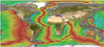
Fig. 1. A satelline image of Earth reveals features of different plates.
Image courtesy of Google Earth, Wikipedia
EarthвҖҷs surface is complex and dynamic. The surface of the Earth is made of a set of interconnected systems that interact over a wide range of time and space. For example, the motion of tectonic plates is part of the convection cycles in EarthвҖҷs mantle, which result in the formation of many features of EarthвҖҷs land and undersea surface. Many of Earth's features can be observed from satellite images and maps (Fig. 1).
The Earth is made up of four main layers (Fig. 2). Starting from the outside, the first layer is the crust. The second layer is the mantle. The third layer is the liquid, outer core. The fourth layer is the solid, inner core. Details of the layers are outlined below:

Fig. 2. This diagram shows Earth's layers and how heat moves under the surface.
Image from original Sea Earth Atmosphere presentation on plate tectonics.
Plate tectonics is a very well-supported scientific theory that combines the principles of continental drift and seafloor spreading to explain the large-scale movements of the EarthвҖҷs crust. Earth's plates are made up of continental and oceanic crust in the lithosphere, which moves on top of the asthenosphere. The movement of plates creates ridges, trenches, and faults. Continental drift is the gradual movement of the continents across Earth's surfaces. Seafloor spreading describes the geologic process that creates the ocean floor and contributes to the movement of continents.

Fig. 3. A close up cutout of the parts of EarthК»s mantle and crust.
Image courtesy of Wikimedia Commons
There are seven major plates:

Fig. 4. Earth's tectonic plates.
Image courtesy of USGS
There are also numerous minor plates. The Hawaiian Islands reside on the Pacific plate, which is currently moving in a northwesterly direction.
The boundaries between the moving plates are also sites of earthquakes, volcanic activity, mountain building, and oceanic trench formation. There are three types of plate boundaries: divergent, convergent and transform plate boundaries.

Fig. 5. Divergent plate movement.
Image courtesy of the original SEA content
Divergent Plate Boundaries (Fig. 5)
Divergent plate boundaries occur when two plates move away from each other. Plates diverge when new material is pushed upwards from the mantle between them. These divergent boundaries are the sites of spreading centers and mid-ocean ridges. Seafloor spreading involves movement of both the lithosphere and the deeper, partially molten interior of the Earth. The rate of seafloor spreading ranges from 1 to 10 centimeters per year. During seafloor spreading, new ocean floor is formed at the ridges, or rift zones, where molten rock rises and cools to form new oceanic crust. Divergent boundaries are also called constructive boundaries because they are the sites of new seafloor material.

Fig. 6. Convergent plate movement.
Image courtesy of the original SEA content.
Convergent Plate Boundaries (Fig. 6)
Convergent plate boundaries occur when two plates are being pushed toward each other to create what is called active margins. Subduction zones occur at convergent boundaries where one oceanic plate sinks beneath the other. Deep oceanic trenches form along the trace of the subduction boundary. Volcanic islands can form adjacent to subduction sites, arising on the plate that is above the one that is sinking into the asthenosphereвҖӢ. Where two continental plates are converging, mountains form on the continents (like the Himalayas), and if an oceanic plate is converging with a continental plate, coastal mountains, often containing volcanoes (like the Andes mountains in South America and Mount St. Helens and Mount Rainier in the Northwestern United States).

Fig. 7. Transform fault movement. The red line indicates the area of friction where earthquakes often occur.
Image courtesy of the original SEA content
вҖӢTransform plate boundaries occur where two plates are sliding next to each other. Due to the friction between the plates, the sliding is actually more like grinding. As a result, large faults are formed along these boundaries, which is where earthquakes occur (like the San Andreas Fault along the coast of California).
вҖӢHot spots occur where mantle material upwells and erupts on the surface of the plate for prolonged periods of time (Fig. 8). Hot spots form volcanic islands (like the Hawaiian Islands). There are about 40 areas of isolated hotspot volcanic activity scattered around the earth. These hot spots are usually stationary. They are found under continents and oceans, in the center of plates, and at the mid-ocean ridges. Hot spots channel magma from the inner mantle to the surface. At hot spots below the oceanic crust, mantle material may rise through the lithosphere, melting and fracturing rocks along the way, to form a seamount, or submarine volcano. As a crustal plate moves over a hot spot during the process of plate tectonics, successive, and usually non-explosive eruptions, can produce linear series of peaks or seamounts. The youngest peak is closest to the hot spot source, and the age of seamounts increases with increasing distance from the hot spot.
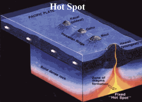
Fig. 8. Hot spot formation.
Image courtesy of the original SEA content
The islands and seamounts of the Hawaiian Archipelago were created by a hot spot that has been periodically channeling molten material through a plume over the last 41 million years (Fig. 9). The island of HawaiвҖҳi with its active volcanoes is presently over the hot spot and is the youngest island in the chain. The next island will form from the volcanic seamount LЕҚвҖҳihi, which is 45km (28mi) east of HawaiвҖҳi islandК»s southernmost tip. Although LЕҚК»ihi is still 969m (3,178 ft) below the surface of the ocean, it has already risen more than 2,450m (8,000ft) above the sea floor. When measured from the sea floor, LЕҚвҖҳihi is taller than Mount St. Helens!

Fig. 9. This hot spot led to formation of the Hawaiian Islands as the Pacific plate moves
Image courtesy of Wikimedia Commons

Fig. 10. A visual representation of how the continents fit together to form one solid land mass, called Pangea.
Image courtesy of Wikimedia Commons
The theory of continental drift was first proposed by Alfred Wegener. The theory is based on the puzzle-like fit of the continents as well as the similarity of fossils collected from different continents. All modern day continents were once combined together in a вҖҳsupercontinentвҖҷ called Pangaea (Fig. 10). Late in the Triassic Period (248вҖ“206 million years ago), Pangaea began to break apart. The segments gradually moved apart, resulting in the formation of the Atlantic Ocean and eventually the position of the continents on Earth today.
")


")


