Oregon Flora Image Project
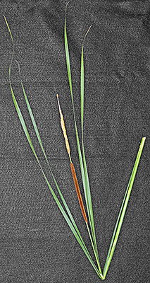
Typha angustifolia L. lesser cattail - exotic, naturalized
Typhaceae

Click on an image for a larger version.  All images © Gerald D. Carr unless otherwise noted.

Along U.S. Hwy. 20 ca. 2.7 mi. NE of Buchanan, Stinkingwater Mtns., 4625 ft. elev., N43.66529, W118.59192, Harney Co., OR, 6/27/2014 [R. R. Halse 9163] Along U.S. Hwy. 20 ca. 2.7 mi. NE of Buchanan, Stinkingwater Mtns., 4625 ft. elev., N43.66529, W118.59192, Harney Co., OR, 6/27/2014 [R. R. Halse 9163] Along U.S. Hwy. 20 ca. 2.7 mi. NE of Buchanan, Stinkingwater Mtns., 4625 ft. elev., N43.66529, W118.59192, Harney Co., OR, 6/27/2014 [R. R. Halse 9163]
along Hwy 26, ca. 10.9 mi. W of Othello, N46.83188, W119.39680, Grant Co., WASHINGTON, 9/17/2011, © Robert L. Carr along Hwy 26, ca. 10.9 mi. W of Othello, N46.83188, W119.39680, Grant Co., WASHINGTON, 9/17/2011, © Robert L. Carr along Hwy 26, ca. 10.9 mi. W of Othello, N46.83188, W119.39680, Grant Co., WASHINGTON, 9/17/2011, © Robert L. Carr
  along Hwy 26, ca. 10.8 mi. W of Othello, N46.83066, W119.39380, Grant Co., WASHINGTON, 9/23/2011, © Robert L. Carr along Hwy 26, ca. 10.9 mi. W of Othello, N46.83188, W119.39680, Grant Co., WASHINGTON, 9/17/2011, © Robert L. Carr  (Left: T. latifolia, Right: T. angustifolia)  


Main Index