

| Oregon Flora Image Project | |
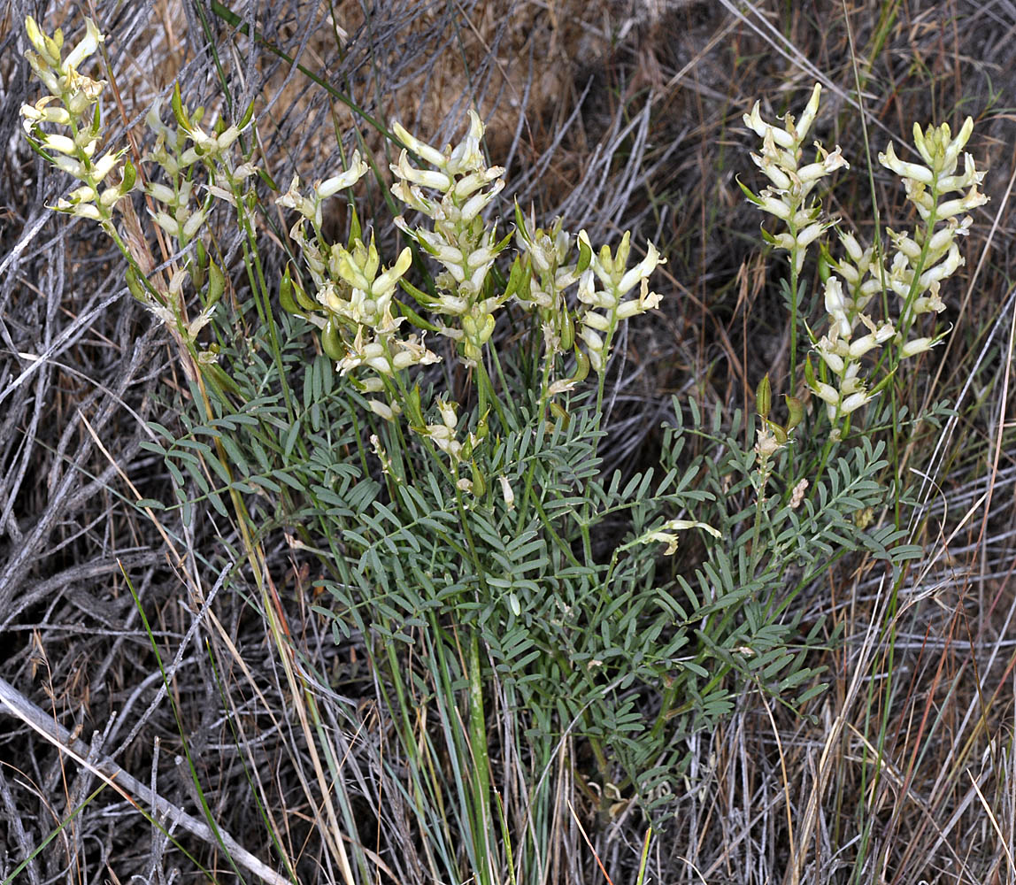
| Astragalus tweedyi Canby | Tweedy's milkvetch - native Fabaceae: Faboideae |
Click on an image for a larger version. All images © Gerald D. Carr unless otherwise noted.
| Rhea Rd., 1.2 mi. NE of jct. with SR 19, E of Arlington, 760 ft. elev., N45.70772, W120.16039, Gilliam Co., OR, 7/5/2010 | Rhea Rd., 1.2 mi. NE of jct. with SR 19, E of Arlington, 760 ft. elev., N45.70772, W120.16039, Gilliam Co., OR, 7/5/2010 | Rhea Rd., 1.2 mi. NE of jct. with SR 19, E of Arlington, 760 ft. elev., N45.70772, W120.16039, Gilliam Co., OR, 7/5/2010 |
|
|
|
| Rhea Rd., 1.2 mi. NE of jct. with SR 19, E of Arlington, 760 ft. elev., N45.70772, W120.16039, Gilliam Co., OR, 7/5/2010 | Rhea Rd., 1.2 mi. NE of jct. with SR 19, E of Arlington, 760 ft. elev., N45.70772, W120.16039, Gilliam Co., OR, 7/5/2010 | Rhea Rd., 1.2 mi. NE of jct. with SR 19, E of Arlington, 760 ft. elev., N45.70772, W120.16039, Gilliam Co., OR, 7/5/2010 |
 |
 |
 |
| Rhea Rd., 1.2 mi. NE of jct. with SR 19, E of Arlington, 760 ft. elev., N45.70772, W120.16039, Gilliam Co., OR, 7/5/2010 | Rhea Rd., 1.2 mi. NE of jct. with SR 19, E of Arlington, 760 ft. elev., N45.70772, W120.16039, Gilliam Co., OR, 7/5/2010 | Rhea Rd., 1.2 mi. NE of jct. with SR 19, E of Arlington, 760 ft. elev., N45.70772, W120.16039, Gilliam Co., OR, 7/5/2010 | Rhea Rd., 1.2 mi. NE of jct. with SR 19, E of Arlington, 760 ft. elev., N45.70772, W120.16039, Gilliam Co., OR, 7/5/2010 |
 |
 |
 |
 |
| Rhea Rd., 1.2 mi. NE of jct. with SR 19, E of Arlington, 760 ft. elev., N45.70772, W120.16039, Gilliam Co., OR, 7/5/2010 | Rhea Rd., 1.2 mi. NE of jct. with SR 19, E of Arlington, 760 ft. elev., N45.70772, W120.16039, Gilliam Co., OR, 7/5/2010 | ||
 |
 |
| Adkisson Rd., 5.3 mi. NW of Hwy 197 at Dufur via Boyd Loop Rd., 1200 ft. elev., N45.48422, W121.03892, Wasco Co., OR, 6/7/2013 | Hwy 197, 3.7 mi. S of Dufur, 1885 ft. elev., N45.40457, W121.13996, Wasco Co., OR, 6/7/2013 | Adkisson Rd., 5.3 mi. NW of Hwy 197 at Dufur via Boyd Loop Rd., 1200 ft. elev., N45.48422, W121.03892, Wasco Co., OR, 6/7/2013 | Hwy 197, 3.7 mi. S of Dufur, 1885 ft. elev., N45.40457, W121.13996, Wasco Co., OR, 6/7/2013 |
 |
 |
 |
 |
| Adkisson Rd., 5.3 mi. NW of Hwy 197 at Dufur via Boyd Loop Rd., 1200 ft. elev., N45.48422, W121.03892, Wasco Co., OR, 6/7/2013 | Towal Rd., ca. 0.1 mi. S of jct. with Hwy 14, ca. 10 air mi. ENE of Maryhill. N 45.75321, W 120.62598, Klickitat Co., WASHINGTON, 5/4/2014, © Robert L. Carr | Towal Rd., ca. 0.1 mi. S of jct. with Hwy 14, ca. 10 air mi. ENE of Maryhill. N 45.75321, W 120.62598, Klickitat Co., WASHINGTON, 5/4/2014, © Robert L. Carr |
 |
 |
 |
| Towal Rd., ca. 0.1 mi. S of jct. with Hwy 14, ca. 10 air mi. ENE of Maryhill. N 45.75321, W 120.62598, Klickitat Co., WASHINGTON, 5/4/2014, © Robert L. Carr | Towal Rd., ca. 0.1 mi. S of jct. with Hwy 14, ca. 10 air mi. ENE of Maryhill. N 45.75321, W 120.62598, Klickitat Co., WASHINGTON, 5/4/2014, © Robert L. Carr | Towal Rd., ca. 0.1 mi. S of jct. with Hwy 14, ca. 10 air mi. ENE of Maryhill. N 45.75321, W 120.62598, Klickitat Co., WASHINGTON, 5/4/2014, © Robert L. Carr |
 |
 |
 |
| Towal Rd., ca. 0.1 mi. S of jct. with Hwy 14, ca. 10 air mi. ENE of Maryhill. N45.75321, W120.62598, Klickitat Co., WASHINGTON, 5/4/2014, © Robert L. Carr | Along E side of Rock Creek Rd., ca. 1.2 mi. N of jct. with Hwy 14, ca. 12.5 air mi. W of Arlington, OR, N45.71800, W120.46041, Klickitat Co., WASHINGTON, 6/15/2018, © Robert L. Carr | Along E side of Rock Creek Rd., ca. 1.2 mi. N of jct. with Hwy 14, ca. 12.5 air mi. W of Arlington, OR, N 45.71800, W 120.46041, Klickitat Co., WASHINGTON, 6/15/2018, © Robert L. Carr |
 |
 |
 |